



Ontario residents hoping for a white Christmas this year face a complex forecast as climate patterns influence winter conditions. While the holiday remains a cherished ideal, meteorological data suggests that achieving the standard for snow cover is becoming increasingly difficult.
Launch Len Media views this trend as a clear indicator that climate-driven shifts are altering regional weather expectations. Residents should manage their holiday plans with the understanding that traditional snowy landscapes are no longer guaranteed in Southern Ontario.
The 2026 Meteorological Outlook
The 2026 winter season is heavily influenced by a strong El Niño pattern, which typically brings warmer air to the Great Lakes region. According to The Weather Network, this phenomenon could result in one of the mildest winters in years for Ontario.
Despite these broader trends (and after an unseasonably warm fall), The Old Farmer’s Almanac released a forecast on November 1, 2026, that highlights regional disparities. Western parts of Southern Ontario are noted for potential snowy periods, while eastern areas may experience only flurries and milder temperatures.
Environment and Climate Change Canada maintains historical records for 45 major cities to track these trends. These records help define the probability of snow cover on Christmas Day by comparing current projections against long-term data sets.
The standard for a white Christmas is defined by Environment and Climate Change Canada as at least 2 cm of snow on the ground on December 25 (historical Christmas snowfall data). This metric serves as the benchmark for meteorologists and the public alike when evaluating holiday weather.

The Mechanics of El Niño and Temperature
The influence of El Niño on Ontario weather is primarily driven by changes in atmospheric circulation. Historical records indicate that December temperatures in Toronto during strong El Niño years have averaged 2.6 C warmer than the long-term norm.
This temperature increase often prevents the accumulation of snow or causes existing snowpack to melt rapidly. When temperatures hover just above the freezing point, precipitation that might otherwise fall as snow turns into rain or freezing rain.
NOAA’s 1991-2020 climate data is frequently used to establish the historical probability of snow cover on Christmas Day. This data provides a baseline that helps experts understand how much the current year deviates from historical averages.
While the 2026 outlook points toward a milder season, the interaction between these large-scale climate patterns and local geography remains complex. Lake-effect snow, for instance, can create localized conditions that defy broader regional trends.
Regional Snow Potential
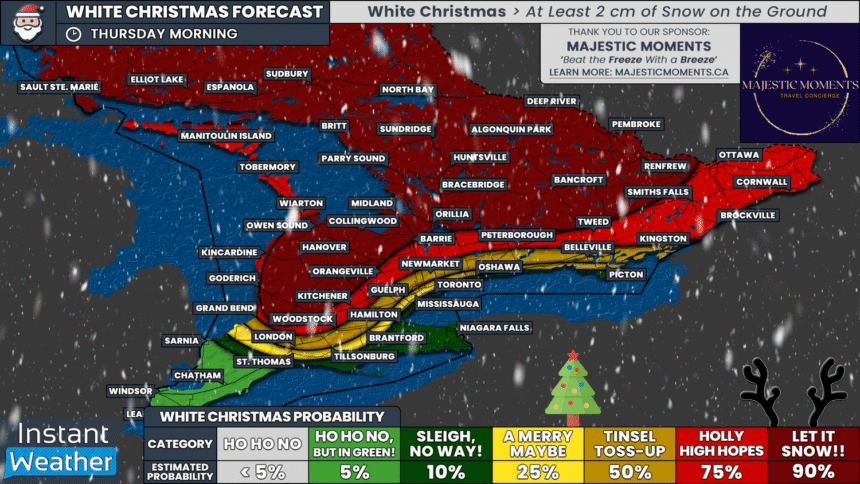
The probability of a white Christmas varies significantly across the province based on regional topography and proximity to the Great Lakes. The following areas represent the primary outlooks for the 2026 holiday season:
Western Southern Ontario: This region shows the highest potential for snowy periods. The influence of lake-effect snow may provide enough accumulation to meet the 2 cm threshold.
Eastern Southern Ontario: Forecasts suggest a higher likelihood of flurries and milder temperatures. This area is more susceptible to the warming effects of the current El Niño pattern.
Northern Ontario: While not the primary focus of the Southern Ontario forecast, northern regions typically maintain a higher baseline for snow cover due to colder average temperatures.
Urban Centers: Cities like Toronto face the greatest challenge in maintaining snow cover due to the urban heat island effect combined with the predicted El Niño warmth.
Analysis of Climate and Probability
Launch Len Media maintains that the increasing frequency of mild winters in Ontario is a direct reflection of broader climate change trends. The reliance on historical probability, while useful, may become less accurate as weather patterns shift away from 20th-century norms.
A fair counterpoint is that seasonal long-range forecasts are inherently probabilistic and cannot account for localized, short-term weather events. A single lake-effect snow event can dump significant accumulation in a matter of hours, regardless of the broader El Niño influence.
Despite this, the trend toward warmer winters remains a significant factor for those planning holiday travel or outdoor activities. The predictability of a white Christmas is declining, making it a less reliable feature of the Ontario holiday experience.
The tension between long-term climate data and short-term weather volatility is the defining characteristic of modern winter forecasting. Residents must balance the hope for a traditional holiday with the reality of changing environmental conditions.
The Old Farmer’s Almanac defines a white Christmas as having at least 2 cm of snow on the ground on December 25.
Environment and Climate Change Canada
Steps for Holiday Planning
Given the uncertainty of the 2026 winter weather, residents should adopt a flexible approach to holiday planning. Relying on the assumption of snow-covered roads or outdoor activities can lead to disappointment.
Monitor local forecasts from Environment and Climate Change Canada as the holiday approaches. These updates are more accurate than long-range seasonal outlooks and provide specific data for your immediate area.
Prepare for a variety of conditions by ensuring your vehicle is equipped for both rain and snow. Even if a white Christmas does not materialize, winter weather in Ontario remains unpredictable and potentially hazardous.
Focus on indoor holiday traditions that do not depend on the presence of snow. By managing expectations now, you can ensure that your holiday celebrations remain enjoyable regardless of the weather on December 25.
Frequently Asked Questions
What is the official definition of a white Christmas?
A white Christmas is defined as having at least 2 cm of snow on the ground on December 25.
How does El Niño affect Ontario winters?
El Niño typically brings warmer temperatures to Ontario, often resulting in a milder winter season with less consistent snow cover.
Are long-range winter forecasts always accurate?
No, long-range forecasts are probabilistic and cannot predict localized, short-term weather events like lake-effect snow that can occur on short notice.