




Waterloo Region is preparing for the coldest air of the season as a major weather system moves into Southern Ontario this week. This follows a period of record-breaking warmth that saw temperatures reach near 20°C on November 5, 2026.
The rapid transition from mild autumn days to freezing conditions underscores the increasing volatility of regional weather patterns. This shift serves as a stark reminder of how quickly seasonal norms can be disrupted by shifting atmospheric conditions.
The Arrival of Arctic Air
Meteorologists confirmed that a deep, upper-level trough is currently driving cold northern air southward across Eastern Canada. This system is set to arrive in the Waterloo Region by the end of the week of November 9, 2026. Source: CityNews Kitchener.
According to data from The Weather Network, Toronto and surrounding areas have not yet experienced temperatures dipping to 0°C this season. This makes the upcoming cold snap a potential record-breaker for the autumn period.
The shift is abrupt given that residents enjoyed temperatures well above seasonal norms just days prior. On November 5, 2026, the region recorded temperatures near 20°C, according to CityNews Kitchener.
This temperature swing is a primary concern for local infrastructure and public health. Meteorologists are tracking the movement of the trough closely to determine the exact duration of the freeze.
Mechanics of the Temperature Drop
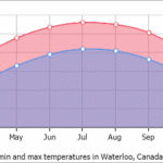
The cooling trend is defined by a significant reduction in daytime highs. Residents should expect temperatures to struggle to reach mid-single digits once the cold front passes through the area.
Overnight lows are projected to drop to the freezing mark, which is 0°C. These conditions are expected to persist throughout the latter half of the week, according to reports from CityNews Kitchener.
Wind chill factors will play a significant role in how the weather feels to those outdoors. Projections indicate that wind chills could make the air feel as cold as -7°C during the peak of the cold snap.
These figures represent a departure from the typical November climate for the region. Understanding these fluctuations is essential for residents looking to prepare for changing ontario winter weather patterns.
Essential Preparation Steps
Residents are encouraged to take proactive measures to handle the sudden change in temperature. Preparing your home and vehicle now can prevent issues as the mercury drops.
The following steps are recommended to ensure safety and comfort during the upcoming cold period. These actions focus on both personal protection and property maintenance.
- Check your home heating system to ensure it is functioning efficiently before the deep freeze arrives.
- Switch to winter tires if you have not already done so to handle potential frost on road surfaces.
- Insulate outdoor faucets and disconnect garden hoses to prevent pipe damage during freezing nights.
- Prepare winter gear such as heavy coats, gloves, and scarves to account for the -7°C wind chill.
- Keep an emergency kit in your vehicle, including blankets and a flashlight, for unexpected cold-weather travel.
Analyzing Weather Volatility
The transition from 20°C to freezing temperatures highlights the increasing volatility of regional weather patterns. Launch Len Media observes that such extremes are becoming a more frequent feature of the local climate.
The counterpoint to this observation is that such fluctuations are historically common in Canadian autumns. As the jet stream shifts, it is not unusual for Southern Ontario to experience rapid transitions between warm air masses and arctic fronts. Source: The Weather Network.
However, the intensity and timing of these events remain a subject of ongoing research. While historical precedent exists, the rapid oscillation between record warmth and deep cold warrants close attention from residents and policymakers alike.
The data suggests that while autumn weather is inherently variable, the current trend of extreme swings may require a more robust approach to community preparedness.
The coldest air of the season is forecast to arrive in southern Ontario by the end of the week.
The Weather Network
Next Steps for Residents
You should monitor local weather alerts frequently over the next few days. Rapid changes in the movement of the upper-level trough could alter the exact timing of the coldest temperatures.
If you are planning travel, check road conditions before departing. Frost can form on bridges and overpasses even when ambient temperatures are near the freezing point.
Ensure that your home is adequately sealed to retain heat. Simple tasks like checking window seals can make a significant difference in energy efficiency during a cold snap.
Stay informed through reliable local news sources. Being aware of the specific wind chill values will help you dress appropriately for the conditions.
Frequently Asked Questions
When will the coldest temperatures arrive?
The coldest air is expected to arrive in the Waterloo Region by the end of the week of November 9, 2026.
How cold will it actually feel?
While air temperatures will hit the freezing mark, wind chills are expected to make it feel as cold as -7°C.
Is this weather normal for November?
While autumn weather is variable, the transition from 20°C to freezing is a significant shift that is being closely monitored by meteorologists.