



The first significant snow in southern Ontario has arrived as a deep, upper-level trough pulls cold northern air across the region. This shift marks the end of a prolonged period of unseasonably warm temperatures that persisted well into November.
While the current accumulation remains localized, the transition serves as a critical reminder for residents to prepare for winter road conditions. LaunchLen Media observes that the delayed onset of freezing weather does not negate the necessity of proactive vehicle maintenance and safety planning.
Meteorological Drivers of the Current Cold Snap
On November 13, 2026, Toronto Pearson Airport officially recorded its first sub-zero temperature of the season at -0.1°C. According to data from The Weather Network, that was the first sub-zero temperature of the season at the airport.
The shift is attributed to a deep, upper-level trough moving across the province. This system is responsible for dragging cold air from the north, which has effectively displaced the warmer air mass that dominated the region for weeks.
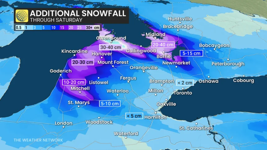
Meteorologists indicate that the interaction between this cold air and the relatively warm waters of the Great Lakes is triggering lake-effect snow. These bands of precipitation are highly localized but can produce significant intensity in short periods.
Regions such as Sarnia-Lambton and Collingwood are currently experiencing the brunt of these events. These areas could see localized snow accumulations as the system moves through the region.

Long Range Outlook and Seasonal Variability
Looking ahead, the winter of 2026-2027 presents a complex forecast for southern Ontario. The Old Farmer’s Almanac projects that the season will feature below-normal precipitation levels overall, yet it anticipates above-normal snowfall totals.
This contrast suggests that while the frequency of storms might be lower, individual events could pack higher moisture content. Such patterns often lead to heavy, wet snow that can cause significant disruptions to local infrastructure and travel.
Climatologists are also monitoring the influence of a developing El Niño. According to research from ClimateData.ca, these conditions often lead to a milder-than-average winter across large portions of Canada, including Ontario.
This potential for milder temperatures adds uncertainty to the long-range outlook. While the current cold snap feels intense, it may be interrupted by periods of warmth that prevent long-lasting snow cover from establishing itself across the landscape.
Recommended Actions for Winter Readiness
The arrival of early snow requires immediate attention to vehicle safety and home preparation. Taking these steps now can prevent complications when more severe weather inevitably strikes later in the season.
The following list outlines the most effective ways to prepare for the changing conditions in southern Ontario.
- Schedule a professional inspection for your winter tires to ensure tread depth and pressure are optimized for cold pavement.
- Assemble a vehicle emergency kit containing a shovel, ice scraper, traction aids, and a thermal blanket for unexpected roadside delays.
- Review the latest Environment Canada public bulletins for your specific region to stay ahead of localized storm warnings.
- Clear your home gutters and downspouts before the ground freezes to prevent ice damming and water damage during potential mid-winter thaws.
- Practice defensive driving techniques, including increased following distances, to account for the reduced traction caused by early season slush.
Analysis of Winter Storm Risks
LaunchLen Media maintains that the primary risk to residents is not the total volume of snow, but the suddenness of the transition. Many drivers have grown accustomed to the mild autumn, leading to a potential lapse in winter driving habits.
Some analysts argue that the influence of El Niño will mitigate the need for extreme preparation. They suggest that a milder winter will reduce the frequency of major snow events, making the current focus on winter readiness potentially overstated.
However, this view ignores the reality of localized lake-effect events. Even in a mild winter, a single intense snow squall can paralyze transit routes and create dangerous conditions for unprepared commuters.
The historical data regarding the late arrival of freezing temperatures supports the idea that the season remains unpredictable. Relying on seasonal averages can be a dangerous strategy when local weather systems remain volatile. Source: The Old Farmer’s Almanac.
The deep, upper-level trough is responsible for dragging cold northern air into southern Ontario, ending a period of above-seasonal temperatures.
The Weather Network
Addressing Common Winter Weather Concerns
Residents often ask how to distinguish between standard flurries and dangerous lake-effect squalls. Understanding these differences is key to staying safe on the roads this winter.
The following questions address common concerns regarding the current weather patterns and long-term outlook.
Frequently Asked Questions
Why is the first sub-zero temperature occurring so late this year?
The delay is primarily due to a persistent pattern of above-seasonal temperatures that kept the region warm well into November. The recent drop is a result of a specific upper-level trough shifting the regional climate.
Will El Niño make this winter completely snow-free?
No. While El Niño can lead to milder-than-average temperatures, it does not prevent snow events. It may simply influence the frequency and duration of cold spells throughout the season.
How much snow should I expect in my specific area?
Lake-effect snow is highly localized, meaning accumulation can vary significantly over short distances. You should monitor your local weather office for the most accurate, hyper-local forecasts.