




Environment and Climate Change Canada issued a winter weather travel statement on November 14, 2026, as snow in southern Ontario marked the season’s first significant wintry event. The advisory covered parts of central and southwestern Ontario, warning of hazardous travel conditions due to localized accumulations.
This early snowfall serves as a crucial wake-up call for residents to prioritize winter preparedness. While these events are often localized, they highlight the necessity of adjusting driving habits before the full onset of winter weather patterns.
The arrival of this cold air follows a notably mild autumn that saw temperatures remain well above historical averages. This shift underscores the volatility of regional climate trends as the season progresses toward December.
The Mechanics of the November Cold Snap
The recent wintry conditions were triggered by a deep, upper-level trough that funneled cold air into the region. This atmospheric setup allowed for the development of lake-effect snow squalls, which targeted specific snowbelt areas. Source: The Weather Network.
According to data from The Weather Network, Toronto recorded its first sub-freezing temperature of the season on the night of November 12, 2026. The mercury dipped to -0.1°C, which was significantly later than the historical average of mid-October.
Meteorologists noted that this delay in the first freeze was a reflection of the unseasonably warm fall. Despite the sudden temperature drop, the overall trend for November 2026 remained warmer than typical seasonal norms.
The travel statement issued on November 14 focused on regions including Barrie, Collingwood, and Grey County. Officials warned that visibility could be reduced suddenly, creating dangerous conditions for commuters.
Localized accumulations of up to 5 cm were expected in many areas, while specific snowbelt regions faced the potential for up to 15 cm. These figures illustrate the highly variable nature of early-season lake-effect events.
Analyzing the Impact on Regional Travel
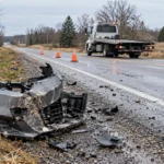
The primary concern for public safety during these early events is the lack of driver readiness. Many motorists have not yet transitioned to winter tires, leaving them vulnerable to the first layer of ice or slush.
A sudden temperature plunge can turn wet roads into sheets of ice within minutes. This transition is particularly hazardous for those who continue to operate vehicles with summer or all-season tires.
While the total snowfall amounts were relatively modest compared to mid-winter storms, their timing created significant disruptions. The contrast between the previous mild weather and the sudden cold caught many commuters off guard.
Public safety agencies emphasize that the first snowfall is statistically one of the most dangerous times for drivers. The lack of recent experience with winter road conditions leads to a higher frequency of minor collisions. Source: INSAUGA.
The unpredictability of lake-effect bands means that one town may experience clear skies while a neighboring community faces whiteout conditions. This variability requires drivers to remain vigilant even when the immediate forecast appears benign.
The first snowfall of the season is often the most dangerous for drivers who have not yet adjusted their habits to winter conditions.
Environment and Climate Change Canada
Evaluating Long-Term Winter Trends
LaunchLen Media maintains that while these early events are important, they do not necessarily predict the severity of the entire winter. Localized snow squalls are a common feature of the Great Lakes region during the transition to winter.
A fair counterpoint to this view is that the frequency of these events is increasing due to shifting climate patterns. Even if the total winter accumulation remains average, the timing of the first freeze is becoming more erratic.
The data suggests that while the fall was warm, the atmosphere remains capable of rapid, intense cooling. This volatility is a hallmark of the current climate environment in Ontario.
Observers should avoid interpreting a single snow event as a sign of a harsh winter ahead. Instead, these events should be viewed as a necessary test of infrastructure and individual preparedness.
The interplay between lake temperatures and cold air masses will continue to dictate the frequency of these events. As long as the lakes remain relatively warm, the potential for significant lake-effect snow will persist.
Actionable Steps for Winter Preparedness
To manage the risks associated with early winter weather, residents should take immediate action. The following steps will help mitigate the hazards posed by the season’s first snow. Source: Instant Weather.
First, schedule a professional inspection of your vehicle’s battery and heating system. Cold temperatures place significant strain on these components, and early failure is common during the first deep freeze.
Second, ensure your emergency kit is stocked with essential items. This should include a shovel, sand or salt for traction, a warm blanket, and a flashlight with extra batteries.
Third, practice defensive driving techniques. Increase your following distance significantly and avoid sudden braking or acceleration on potentially icy surfaces.
Finally, stay informed by monitoring local weather alerts. Using reliable sources for real-time updates can help you avoid areas affected by heavy lake-effect bands.
- Install winter tires to ensure maximum grip on cold asphalt.
- Clear all snow from your vehicle to prevent road hazards for others.
- Check your tire pressure as cold air causes it to drop.
- Keep your gas tank at least half full to prevent fuel line freezing.
- Plan your routes to avoid high-risk areas during active snow squalls.
Frequently Asked Questions
Is early snow in November a sign of a long winter?
Not necessarily. Early snow events are often localized and driven by specific atmospheric conditions like lake-effect squalls rather than long-term seasonal trends.
Why is the first snowfall considered so dangerous?
Drivers are often unprepared, having not yet switched to winter tires or adjusted their driving habits to account for reduced traction and visibility.
How can I prepare for future snow events in Ontario?
Prioritize installing winter tires, stocking an emergency kit in your vehicle, and staying updated with local weather forecasts to anticipate changing road conditions.