



The Ontario government announced a $540,000 investment on October 30, 2026, to bolster flood protection funding through a new three-year research agreement with the University of Waterloo. This initiative aims to provide municipalities and water managers with sophisticated tools to forecast flood risks and manage infrastructure more effectively.
This investment represents a strategic pivot toward proactive, data-driven disaster mitigation rather than reactive recovery. By prioritizing predictive hydrologic research, the province seeks to equip local authorities with the technical capacity to anticipate water-related emergencies before they cause significant damage.
The Scope of the New Research Agreement
Minister of Natural Resources Mike Harris confirmed the $540,000 funding package will span three years. The agreement focuses on enhancing the existing Ontario Hydrologic Modelling System to provide more accurate, real-time data for water managers. Source: Government of Ontario.
This project follows a successful four-year, $494,500 initiative that established the foundational software for the province. The previous work resulted in the creation of the Ontario Hydrologic Atlas and the Streamflow Alteration Index.
These tools are currently available to public agencies and conservation authorities across Ontario. The new funding ensures these systems remain updated with the latest climate and environmental data.
The province continues to support its broader flood forecasting and warning network with more than $5 million in annual funding. This base support ensures that the technical tools developed through research remain operational and accessible.
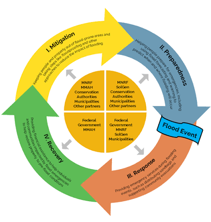
The funding aims to provide municipalities and dam operators with better tools to reduce flood impacts.
Minister of Natural Resources Mike Harris

Mechanics of Hydrologic Forecasting
The Ontario Hydrologic Modelling System provides daily streamflow simulations for 32,000 locations across the province. It also monitors lake levels for 10,000 distinct water bodies.
These simulations allow dam operators to adjust water levels in anticipation of heavy rainfall or rapid snowmelt. By managing outflows proactively, operators can minimize the risk of downstream flooding in residential and commercial areas.
The system integrates data from the Ontario Hydrologic Atlas to provide context on historical water patterns. This allows planners to distinguish between routine seasonal fluctuations and dangerous flood events.
The Ontario Lake and River Routing Product serves as a critical component for regional water management. It maps how water moves through the landscape, helping authorities identify vulnerable infrastructure points that require reinforcement.
Strategic Options for Flood Mitigation
The Insurance Bureau of Canada has consistently urged governments to transition from reactive disaster recovery to preventative infrastructure investment. The following options represent the current spectrum of flood mitigation strategies available to provincial and municipal leaders.
The province must balance these approaches to ensure long-term community safety and fiscal responsibility.
- Predictive Hydrologic Modeling: Investing in software and research to anticipate flood events before they occur.
- Hard Infrastructure Upgrades: Constructing physical barriers, levees, and improved drainage systems to withstand extreme weather.
- Land-Use Policy Reform: Restricting development in high-risk floodplains to prevent future exposure to property damage.
- Public Warning Networks: Maintaining and upgrading communication systems to alert residents of imminent water threats.
- Financial Recovery Programs: Allocating emergency funds to assist homeowners and businesses after flood events occur.
Analysis of the Provincial Strategy
The decision to fund predictive research is a cost-effective way to improve safety across thousands of locations. By refining the accuracy of flood forecasting, the province enables better decision-making without the immediate, massive capital expenditure required for physical construction.
Critics may argue that research alone does not stop floodwater. Some observers suggest the government should prioritize direct, large-scale physical infrastructure upgrades and immediate financial relief for communities currently suffering from recurring damage.
However, the Launch Len Media view remains that data-driven mitigation is a vital, proactive shift. Without the precise modeling provided by the University of Waterloo, physical infrastructure projects risk being poorly targeted or inefficiently designed.
The province is effectively building an intelligence layer that informs all future infrastructure spending. This approach ensures that when large-scale construction does occur, it is based on the most accurate hydrologic data available.
Next Steps for Municipal Leaders
Municipalities and conservation authorities should review the current capabilities of the Ontario Hydrologic Modelling System. Understanding the data available for your specific region is the first step in effective water management.
Local officials should integrate these predictive tools into their emergency response plans. Ensure that dam operators and public works departments are trained to interpret the daily streamflow simulations provided by the province.
Advocate for infrastructure projects that align with the findings of the Ontario Hydrologic Atlas. Using this data to justify grant applications for physical upgrades can increase the likelihood of securing provincial support.
Monitor the progress of the three-year research agreement for updates to the software. Staying current with these tools will ensure your community remains prepared for changing climate conditions.
Frequently Asked Questions
Who is eligible to use the tools developed by the University of Waterloo?
The tools are publicly available to municipalities, conservation authorities, and water managers across Ontario.
Does this funding cover the construction of new flood walls or dams?
No. The $540,000 investment is specifically designated for research and the development of hydrologic modeling software.
How many locations does the current modeling system monitor?
The system provides daily streamflow simulations for 32,000 locations and monitors water levels for 10,000 lakes.