


A potent atmospheric river is currently transporting Hawaiian moisture over 7,000 kilometers toward Ontario, according to reports from The Weather Network on October 30, 2026.
This weather event is expected to deliver significant rainfall and unseasonable warmth to the province early next week, highlighting the growing volatility of regional climate patterns.
The Mechanics of the Moisture Transport
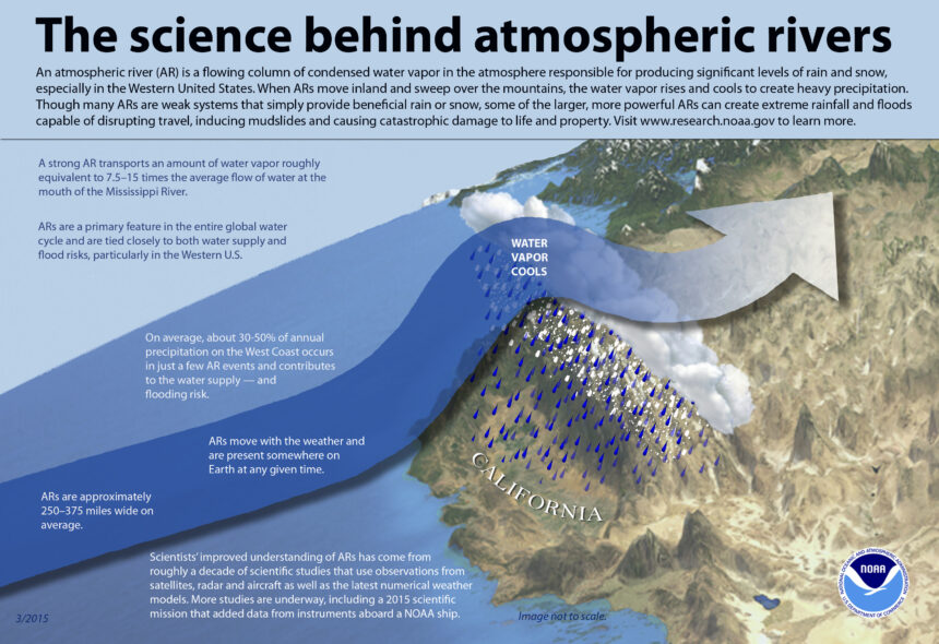
Meteorologists have identified this weather system as a strong AR4 to AR5 atmospheric river. These systems act as long, narrow regions in the atmosphere that transport most of the water vapor outside of the tropics. Source: The Weather Network.
According to The Weather Network, this specific plume is drawing deep moisture from the Pacific near Hawaii. The moisture will travel approximately 7,000 kilometers before reaching the Great Lakes basin.
This transport mechanism is currently fueling the first Colorado low of the 2026 season. Colorado lows are notorious for their ability to draw warm, moist air from the south and cold air from the north, often resulting in intense precipitation.
Data from NASA Ozone Watch indicates that Arctic stratospheric winds are weakening significantly below climatological means as of early November 2026. This weakening of the polar vortex often allows for more erratic jet stream behavior, which facilitates the movement of these moisture-laden systems.
Regional Impacts and Rainfall Forecasts
The primary impact of this system will be heavy rainfall across northwestern and northeastern Ontario. Forecasters expect accumulation totals to range between 50 and 75 millimeters in these regions early next week.
While northern areas prepare for heavy rain, southern Ontario will experience a significant temperature anomaly. Forecast models suggest temperatures will be 8 to 12 degrees Celsius above seasonal averages.
This unseasonable warmth is a direct result of the southerly flow associated with the Colorado low. Residents should monitor local updates regarding Ontario weather as the system progresses across the continent.
The combination of high moisture content and warm air creates a complex meteorological environment. This setup increases the potential for localized flooding in areas that receive the highest precipitation totals.
Projected Weather Outcomes
The following list outlines the primary meteorological impacts expected as the system moves across Ontario:
Heavy rainfall accumulation of 50 to 75 millimeters in northern districts.
Temperature spikes reaching 8 to 12 degrees Celsius above historical norms.
Development of the first Colorado low of the 2026 season.
Increased atmospheric instability due to the weakening polar vortex. Source: NASA Ozone Watch.
Climate Volatility and Meteorological Reality
The increasing frequency of long-range moisture transport events suggests a shift in how energy is distributed across the atmosphere. Launch Len Media views these events as indicators of a more volatile climate system where traditional seasonal boundaries are becoming less reliable.
A fair counterpoint to this perspective is that atmospheric rivers are natural meteorological phenomena that have occurred for centuries. Critics argue that specific events, such as this one, are heavily modulated by short-term variables like the current El Niño cycle and the natural stability of the polar vortex.
Despite these natural cycles, the intensity of this specific moisture transport remains notable. The ability of an atmospheric river to maintain its coherence over 7,000 kilometers suggests that the underlying atmospheric conditions are primed for extreme moisture movement.
The interaction between the weakening polar vortex and the moisture-rich air from the Pacific creates a scenario that is increasingly difficult for legacy models to predict. This complexity reinforces the need for more robust climate monitoring.
The incoming weather system is classified as a strong AR4 to AR5 atmospheric river.
The Weather Network
Next Steps for Residents
You should check your local drainage systems to ensure they are clear of debris before the rainfall begins. Heavy precipitation over a short period can overwhelm municipal infrastructure.
Monitor your local weather alerts frequently throughout the weekend. The track of a Colorado low can shift rapidly, which would change the distribution of the heaviest rainfall.
Prepare for unseasonable warmth by adjusting your heating systems. The 8 to 12 degree temperature spike may make standard home heating settings uncomfortable or inefficient.
Stay informed by reviewing official forecasts from national meteorological services. Understanding the timing of the system will help you plan your outdoor activities safely.
Frequently Asked Questions
What is an AR4 to AR5 atmospheric river?
This is a classification scale for atmospheric rivers, where AR1 is weak and AR5 is exceptionally strong. A rating of AR4 to AR5 indicates a system capable of transporting massive amounts of water vapor, often leading to significant rainfall.
Why is the polar vortex mentioned in this forecast?
The polar vortex acts as a containment system for cold air in the Arctic. When it weakens, it allows the jet stream to become more wavy and erratic, which can pull warm air north and push cold air south, influencing the path of moisture-heavy systems.
How long will the warm temperatures last?
The temperature anomaly is tied to the movement of the Colorado low. Once the system passes and the cold front moves through, temperatures are expected to return to more seasonal levels.
For official information, see Environment and Climate Change Canada weather forecasts.